Main research areas

Climate impact research and water resources
The regional climate determines the availability of water. Processes in the atmospheric boundary layer together with solar radiation determine the exchange of water and heat between the soil and the atmosphere. Regional precipitation, depending on weather conditions, regulates the soil water balance through evaporation. Changes in the climate can shift this balance towards drier or wetter regional averages. This has an effect on the water balance. We can see this in the shifts in groundwater levels and in the fluctuations in reservoir levels. In our research group, we are taking a quantitative approach to this topic, which is important for our future.
Read more: Reggiani, P., A. Talbi and E. Todini (2022). Towards informed Water Resources Planning, Hydrology, 9(136), DOI: 10.3390/hydrology9080136

Climate impact research and water resources
The figure shows the damage curves for a 100-year maximum flood for different heights of a protective structure. The oblique probability distribution is the 100-year extreme value distribution derived for Altenarhr/Ahr in Germany. The gray shaded areas are the expected damage resulting from the 100-year flood. It can be seen that the assumed risks using the full 100-year maximum value distribution are considerably higher than the risks resulting from using the conventional flood frequency curves for a 1/100-year event, where the expected flood value was derived using the 1-year maximum value distribution.
Read more: Todini, E. and P. Reggiani (2024). Towards a new paradigm in flood risk assessment: from single-valued exceedance probability to expected maximum damages. Water Resources Research, 60(1), e2023WR034477, DOI:10.1029/2023WR034477.

Analysis of uncertainties in the climate forecast
We are leaders in the evaluation of climate projections from the CMIP5 climate model experiments. We use statistical methods to determine the uncertainty of climate projections for temperature, precipitation and evaporation over a broad geographical range. This know-how is essential for estimating climate impacts on agriculture, flood and low water events and determining water availability. The same methods can also be extended to estimate renewable energy production from water, sun and wind for a future climate.
Read more: Reggiani, P., E. Todini, O. Boyko and R. Buizza (2021). Assessing uncertainty for decision-making in climate adaptation and risk mitigation. International Journal of Climatology, 1-22. DOI:10.1002/joc.6996.

Analysis of uncertainties in the climate forecast
We are leaders in the evaluation of climate projections from the CMIP5 climate model experiments. We use statistical methods to determine the uncertainty of climate projections for temperature, precipitation and evaporation over a broad geographical range. This know-how is essential for estimating climate impacts on agriculture, flood and low water events and determining water availability. The same methods can also be extended to estimate renewable energy production from water, sun and wind for a future climate.
Read more: Boyko, O., P. Reggiani and E. Todini (2022). Post-processing climate projections of precipitation for the River Po valley: will Italy's North become water constrained? Hydrology Research, 53(11), 1414-1427, DOI: 10.2166/nh.2022.063.

Process-oriented hydrological modeling
Computer models that simulate surface runoff, groundwater recharge and channel flow are required to determine regional water balances and estimate flood and low water volumes. These hydrological models describe elementary processes of the water cycle using mathematical equations that are solved by computers.
At the chair we have various such models, which we have developed ourselves in the programming languages C/C++ and Python. They can be applied and calibrated to a wide variety of geographical regions. The knowledge for this is taught in the Master's modules. We also use other solutions such as the WASIM-ETH
and TOPKAPI-X
models.

Hydrological modeling
Hydrological modeling for applications in real time, such as flood forecasting, requires continuous updating of the internal states of the calculation model used for this purpose. The update is synchronized with the availability of new measurement data. These come from weather stations or remote sensing. This data must be processed in real time in order to feed it into the model and correct the outputs. If the model were not updated in this way, it would go off track over time and deliver inadequate results. Model errors must always be minimized in real-time forecasts.
In our group, we are carrying out the assimilation of snow and soil moisture data into hydrological forecast models for the Federal Office of Hydrology
as part of the Eumetsat
funded H-SAF project
funded by Eumetsat.

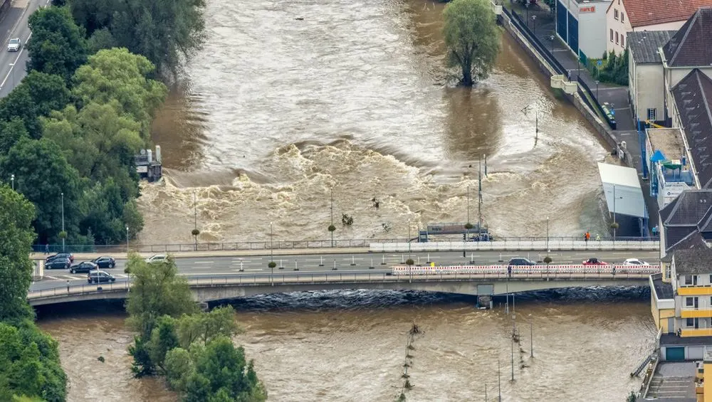
Risk assessment in connection with hydrological extremes
Extreme hydro-meteorological events are due to weather phenomena that occur very rarely by historical standards. They are characterized by exceptionally high temperatures or intense precipitation, often in combination with strong winds. These events can occur suddenly and cause major damage to various sectors of the economy and loss of life. The events in the Ahr catchment area in July 2021
are a good example. The damage can be caused either by water volumes that exceed the absorption capacity of soils and rivers or by drought, which leads to crop losses and water shortages.
Read more: Reggiani, P. and O. Boyko (2019) A Bayesian processor of uncertainty for precipitation forecasting using multiple predictors and censoring, Monthly Weather Review, 147(12) DOI:10.1175/MWR-D19-0066.1.

Risk assessment in connection with hydrological extremes
In a series of projects, we are conducting research on hydrological variability in High Asia, particularly in the catchment areas of the upper Indus and Brahmaputra (Yarlung Tsangpo). These regions belong to the so-called third pole and are susceptible to climatic changes. The variability of water resources could affect millions of people who depend on them for irrigation.
Read more: Reggiani,Reggiani, P. and O. Boyko (2024) A retrospective hydrologic uncertainty analysis using precipitation estimation ensembles for a poorly gauged basin in High Mountain Asia, Journal of Hydrometeorology, DOI: 10.1175/JHM-D-23-0170.1.

Hydrological modeling and weather forecasting
For flood forecasting, weather model outputs must be linked with rainfall-runoff models and channel discharge models for wave propagation in the river channel. Most modern flood early warning systems work on the basis of this principle. With the help of flood early warning systems, it is possible to forecast the rise of a river water level and take appropriate protective measures. These include the erection of mobile flood protection walls
and, in extreme cases, evacuating the population from endangered areas. This has already been done on the Elbe in 2002
and 2013
occurred on the Elbe.
Read more: A. P. de Roo et al. Development of a European flood forecasting system. In: International Journal of River Basin Management 1.1 (2003), pp. 49-59. doi: 10.1080/15715124.2003.

The ensemble forecast
The ensemble forecast
is the weather forecast using multiple (usually 16-51) scenarios from independent model runs, which partially reflect the uncertainty of chaotic weather events. This is comparable to drawing a random variable several times. Weather ensembles can be used to better capture the uncertainties in flood forecasting. This method is now routinely used in operational forecasting on the Rhine by the Federal Institute of Hydrology.
Read more: P. Reggiani, D. Biondi and E. Todini (2024). On time-horizons based post-processing of flow forecasts, Frontiers in Water, DOI: 10.3389/frwa.2024.1359750.

Bayesian statistics for water management risk assessment
Bayesian statistics is based on linking findings from the past with certain a priori assumptions in order to make statements about as yet unknown states or events. This method is widely used in artificial intelligence. At the Chair, we routinely apply Bayesian statistics to flood forecasting in order to draw conclusions about the imminent danger of a future flood event from the historical flood behavior of a river and our proven forecasting capabilities.
Read more: Verkade, J.S., Brown, J. D., F. Davids, P. Reggiani and A. H. Weerts (2017). Estimating predictive hydrological uncertainty by dressing deterministic and ensemble forecasts; a comparison, with application to Meuse and Rhine, Journal of Hydrology, 555, 257-277, DOI:10.2016/j.jhydrol.2017.10.024.
Collaborations, memberships and supervised doctoral theses
The Chair of Water Management Risk Assessment and Climate Impact Research not only works on a regional level, but also contributes to the internalization of the University of Siegen.
Inland
- German Weather Service - Offenbach
- Federal Institute of Hydrology (BfG) - Koblenz
- TU Berlin - Berlin
- Humboldt University of Berlin - Berlin
- Phillips University Marburg - Marburg
- RWTH Aachen University - Aachen
Foreign countries
- Deltares (ex Delft Hydraulics) - Delft, The Netherlands
- Pontifica Universidad Catolica de Valparaiso - Valparaiso, Chile
- Universidad de Talca - Talca, Chile
- University of Bologna - Bologna, Italy
- Universiteit Twente - Twente, The Netherlands
- Universidade Federal do Rio Grande do Sul - Porto Alegre, Brazil
- University of Western Australia - Nedlands, Perth, Australia
- Sant'Anna School of Advanced Studies - Pisa, Italy
- Universita degli Studi di Trento - Trento, Italy
- European Center for Medium Range Weather Forecast - Reading, United Kingdom
- Universidad Autónoma de San Luis Potosí - San Luis Potosí, Mexico
- University of Newcastle - Newcastle, United Kingdom
- Texas A&M University - College Station, Texas, USA
- Universidade Federal de Santa Maria - Santa Maria, Brazil
- Australian National University - Canberra, Australia
University of Siegen (interdisciplinary)
- Stochastics Research Group - Department of Mathematics
- Institute of Biology - Department of Chemistry and Biology
- Institute of Fluid Dynamics and Thermodynamics - Department of Mechanical Engineering
- Institute of Geotechnics - Department of Civil Engineering
- Institute of Design - Department of Mechanical Engineering
- Institute of Mechanics and Control Engineering - Mechatronics - Department of Electrical Engineering
- Chair of Wastewater and Waste Technology - Department of Civil Engineering
- Chair of Water Management Risk Assessment and Climate Impact Research - Department of Civil Engineering
- American Geophysical Union

- Association of Engineers for Water Management, Waste Management and Cultural Engineering e. V.

- German Hydrological Society

- German Association for Water, Wastewater and Waste e. V.

- European Geosciences Union

- World Meteorological Organization

- Societa Idrologica Italiana

- Royal Meteorological Society

-
Dennis Meissner
Sub-seasonal to seasonal hydrological predictions for the German waterways - development of operational services in the face of limitations in predictability (Supervisor: Prof. Paolo Reggiani, Ph.D. - Schools IV of the University of Siegen)
-
Dmitrij Japs:
Extreme weather forecasting form multiple lagged ensemble predictions (Supervisor: Prof. Paolo Reggiani, Ph.D. - Schools IV, University of Siegen)
-
Ward Bahri:
Stochastic management of multipurpose reservoirs (Supervisor: Prof. Paolo Reggiani, Ph.D. - Schools IV, University of Siegen)
-
Héctor Moya:
Soil and land use under the impacts of climate change and agriculture in Chile (Supervisors: Prof. Paolo Reggiani, Ph.D. - Schools IV of the University of Siegen & Prof. Carlos Alberto Huenchuleo Pedreros, Pontificia Universidad Catolica de Valparaiso, Chile)